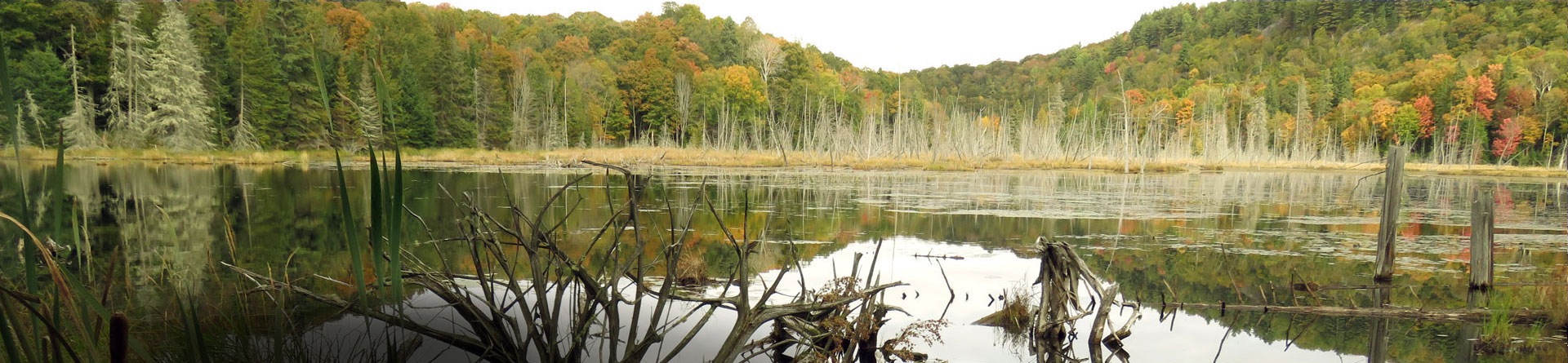
Wetlands
The Highlands Corridor has 4,892 ha of Provincially Significant Wetlands, and 916 ha of candidate Provincially Significant Wetlands and 13,420 ha of unevaluated wetlands. The Highlands Corridor has a regionally high representation of wetlands (17.9%) of which 23% provide highly valuable climate change resilience functions.
Wetlands are one of the most productive and diverse habitats supporting plants, birds, insects, fish and other animals, including 20% of Ontario’s species at risk (Ontario Nature, 2021). Through the provision of clean and abundant water, erosion mitigation, recreational opportunities and other social, cultural and spiritual benefits, wetlands contribute to the quality of life for people in Ontario.
Wetlands also have a critical role in building climate change resilience. As low depressions in the landscape, wetlands capture and absorb surface water during peak runoff, and then slowly release water as the landscape dries. Vegetation found in wetlands (e.g., reeds, sedges and shrubbery) has the ability to slow the flow of surface water; and in some cases wetlands can redirect surface water into the groundwater table through infiltration. These beneficial impacts to the flow of surface water contribute significantly to flood attenuation, underlining the importance of retaining wetlands to diminish the risk of flooding.
Certain wetland types, particularly fens, bogs and coniferous swamps have deep organic deposits and therefore capture and store vast amounts of carbon in the form of peat. In the Highlands Corridor these deposits can be hundreds of hectares in size and tens of metres deep. Changes to water flow and oxygen levels in the wetland through anthropogenic draining or filling has the potential to release this carbon, thereby adding to Canada’s greenhouse gas (GHG) emissions.

Provincially Significant Wetlands in the Highlands Corridor
Recognizing the importance of wetlands, HHLT, Ontario Nature and Glenside Ecological Services Limited evaluated seven large wetland complexes in the Highlands Corridor and the Ministry of Northern Development, Mines, Natural Resources and Forestry (NDMNRF) reviewed the evaluations and classified all seven complexes as Provincially Significant:
- Wright Wetland Complex (Glenside Ecological Services Limited, 2006)
- Milburn Wetland Complex (Glenside Ecological Services Limited, 2017)
- Bark Creek Wetland Complex (Glenside Ecological Services Limited, 2019)
- Kendrick Creek Wetland Complex (Glenside Ecological Services Limited, 2019)
- Lochlin Wetland Complex (Glenside Ecological Services Limited, 2020)
- South Milburn Wetland Complex (Glenside Ecological Services Limited, 2021)
- Laronde Creek Wetland Complex (Glenside Ecological Services Limited, 2022)
Prior to 2000, five additional wetland complexes located around Paudash Lake in eastern Haliburton County were also evaluated and classified as Provincially Significant by the OMNRF.
In total, 12 wetland complexes have been evaluated in or in close proximity to the Highlands Corridor, representing an area of 4,892 ha of Provincially Significant Wetland (See Table 1).
Table 1: Provincially Significant Wetlands in or near the Highlands Corridor
| Wetland | Status | Size (ha) |
| Laronde Creek Wetland Complex | Provincially Significant | 1033 |
| Bark Creek Wetland Complex | Provincially Significant | 762 |
| Milburn Wetland Complex | Provincially Significant | 645 |
| Wright Wetland Complex | Provincially Significant | 200 |
| Kendrick Creek Wetland Complex | Provincially Significant | 849 |
| Lochlin Wetland Complex | Provincially Significant | 855 |
| South Milburn Wetland Complex | Provincially Significant | 18 |
| Central Paudash Lake | Provincially Significant | 79 |
| Inlet Bay - Eastern Paudash Lake Wetland | Provincially Significant | 323 |
| Joe Bay - Paudash Lake Wetland | Provincially Significant | 44 |
| Moxley Lake Wetland | Provincially Significant | 74 |
| Paudash Lake - North Bay Wetland | Provincially Significant | 10 |
| Total | 4,892 |
The Marigold Wetland Complex is also part of the Highlands Corridor. Due to the high number of species at risk identified in this wetland complex, this complex is considered a candidate Provincially Significant Wetland (i.e., if evaluated it would be significant) (See Table 2). The HHLT has initiated an evaluation of the Marigold Wetland Complex with anticipated completion in 2023.
Table 2: Candidate Provincially Significant Wetlands in the Highlands Corridor
| Wetland | Status | Size (ha) |
| Marigold Wetland Complex | Unevaluated | 916 |
| Total | 916 |
Regionally or Locally Significant Wetlands
The NDMNRF has identified new wetland mapping as a priority action required for effective wetland conservation (Ontario Ministry of Natural Resources and Forestry, 2017). To address the paucity of accurate wetland mapping in the County of Haliburton, the HHLT developed and tested a new remote wetland mapping technique to be applied cost-effectively at the landscape level. The test area was defined as the geographic townships of Lutterworth and Snowdon in the Township of Minden Hills, and Glamorgan in the Municipality of Highlands East, all located within the Highlands Corridor.
With the application of a systematic approach and standardized effort and digitizing scale, the HHLT was successful in developing a comprehensive wetland layer with consistently accurate wetland boundaries (Glenside Ecological Services Limited, 2020).
The new wetland mapping identifies a wetland representation in the Highlands Corridor of 17.9%, at an estimated 19,230 ha. The Highlands Corridor is located in Ecoregion 5E where the representation of water (wetlands and lakes) is defined at 11% of the land cover (Crins, Gray, Uhlig, & Wester, 2009). This relatively high representation of wetlands at the regional level, suggests the Highlands Corridor provides a heightened role in the provision of wetland related climate change resilience, and ecological functions and features.
To better understand the climate change related ecoservices associated with the wetlands in the Highlands Corridor, the wetlands were classified to wetland type to identify highly effective flood attenuating wetlands and wetlands with deep organic deposits (i.e.carbon storage). This process identified 23% of the wetlands with these characteristics (Glenside Ecological Services Limited, 2021).